This is an amazing place to live and play, especially if you love hiking or just hanging out and enjoying God’s creation. I have listed my favorite things to do. I started with trails and beaches. Later down the page are the Coos History Museum, Marine Life Center, and Farmer’s market. I ended with things to do in Bandon and Winston. If you want great shopping, go to Eugene or Portland or get on the internet.
South Slough Estuary:
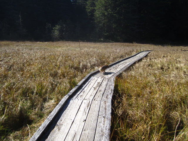
An amazingly gorgeous forest and estuary. There are several trails. The one that starts at the back of the interpretive center is the prettiest and the hardest hike – about 3 miles, steep in parts. There are boardwalks that wind through the fresh and saltwater marshes. There are a few nice lookouts.
Take Cape Arago highway through Charleston. Shortly after leaving that town, take a left on Seven Devils Rd. It’s a few miles. It is well marked. The South Slough is on your left.
http://www.oregon.gov/dsl/SS/Documents/South%20Slough%20508C%20Handout.pdf
The Dunes:
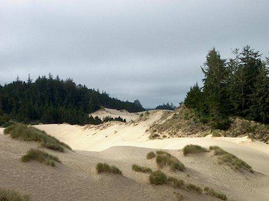
My favorite spot on the dunes has no address, so I will describe how to get there. From North Bend, go north on 101. Cross the McCullough bridge. Take the next left on Trans-Pacific Ln. The sign says “Horsfall Beach.” You will be driving with the bay on both sides of you. Go past the road to Horsfall – don’t take that road. When you see Jordan Cove Rd on the left, look to your right. In a short distance, you will see a place to pull off. Do it. You will then see a trail off to the right of you.
Up that short trail are some of the greatest dunes and views that you will see anywhere. Areas of bare sand hills are interspersed with ponds and dune grass and dune forest. The hills are steep. We used to slide down them in sleds or sand boards when my kids were young. There are no trails. You just walk up and down and all around the dunes. Up on top is a spectacular view of the bay, the bridge, and miles of dunes.
Empire Lakes:
250 Hull Street Coos Bay. There are two lakes. The west lake has a nice paved trail around it. It is mostly flat with a few small hills, maybe 2 miles. If you are in North Bend, going west (towards the beach, away from highway 101) on Newmark, just past the college, turn right on Hull St. There will be a small brown sign that says, I think, “John Topits Park.” If you miss that, you can turn right on Ackerman St. and access the other end of the lake. There is a playground for the kids. Beautiful and peaceful.
Descriptions of Beaches Warning: Remember, NEVER trust the ocean. There are rare sneaker waves that can sweep you off your feet and drag you out. Mostly when people are pulled into the ocean, they drown before the coast guard can get there. If it’s windy or stormy, be extra careful.
Horsfall Beach:
The road to this is just north of McCullough bridge (the big bridge north of town). It costs $5, but there is no place to pay the money. We don’t usually go there because you are supposed to pay, but you can’t. When we go, I just park, and I have never been ticketed. It is an endless sandy beach (like Seaside.)
The following beaches are on Cape Arago Highway, past Charleston. I put them in the order that you get to them. If you drive west on Newmark, it becomes Cape Arago Hwy. Cape Arago Hwy winds around and follows the bay. When you see lots of fishing boats, you know you are in Charleston. It’s kinda fun to walk around the docks and look at the boats. After Charleston, start looking to your right for the following beaches.
Bastendorff:
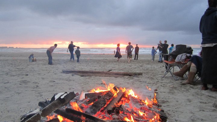
Big sandy beach. Maybe a mile long. It’s right next to where Coos Bay opens into the ocean, so there is a jetty that has great views of all the ships that come into the bay. You can climb up the beach side of the jetty and stand on top, but NEVER climb near the ocean side of the jetty. You don’t want to get washed off. The jetty is an awesome place to watch storms. If you stay in the parking lot and don’t climb on the jetty, it is safe during a storm. HUGE waves crash on the jetty and the cliffs. This is a picture of our church picnic/bonfire on Bastendorff beach. You can park all along the beach on the side of the road. There are outhouses.
Sunset Bay:
Family friendly. Picnic tables. Real restrooms. (not outhouses) It is a bay with rocks, so no rip tide or undertow. You can swim or kayak in this bay. You can park right next to the beach, so this is a good beach if you just want to sit in your car and enjoy the view. It’s less windy that most beaches. It is mostly sandy but has some good tide pools at low tide. On the south end is a grassy place with a pavilion that can be used for your picnic if it is raining. This can be reserved for groups.
Norton’s Gulch:
Between Sunset Bay and Shore Acres, there is a pull-off with a small sign saying “Norton’s Gulch.” It’s easy to miss. There is a short walk down a gulch with a creek to a small beach, part rocky, part sandy. Interesting and relaxing. We have found Native American clay fishing weights here.
Shore Acres:
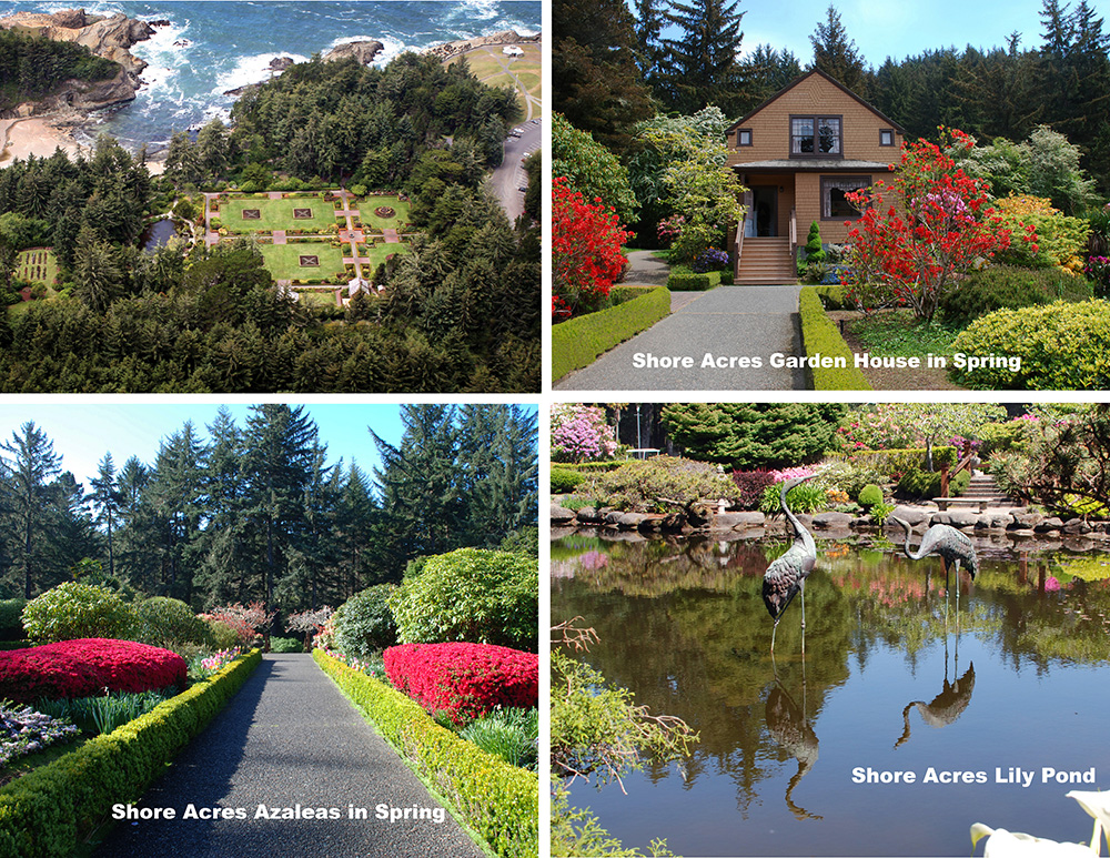
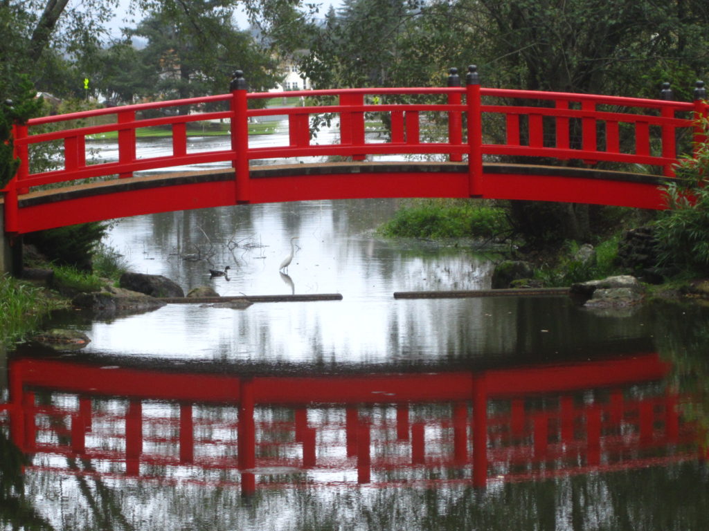
(This description is from their site – see link below. This description is from the internet.) Perched on rugged sandstone cliffs high above the ocean, Shore Acres State Park is an exciting and unexpected combination of beautiful natural and constructed features. It features lushly planted gardens with plants and flowers from all over the world. Something is in bloom almost every day of the year. In the landscaped area you’ll discover a formal garden, a Japanese-style garden with a lily pond, and two rose gardens which include All American Rose Selections. There is a gift shop for souvenirs.
During the Christmas season, they decorate with thousands of beautiful Christmas lights and decorations with an ocean theme.
This is a state park with a $5 per vehicle fee that you pay at the entrance.
There are four places to see there.
- 1. The garden is on the south end of the parking lot.
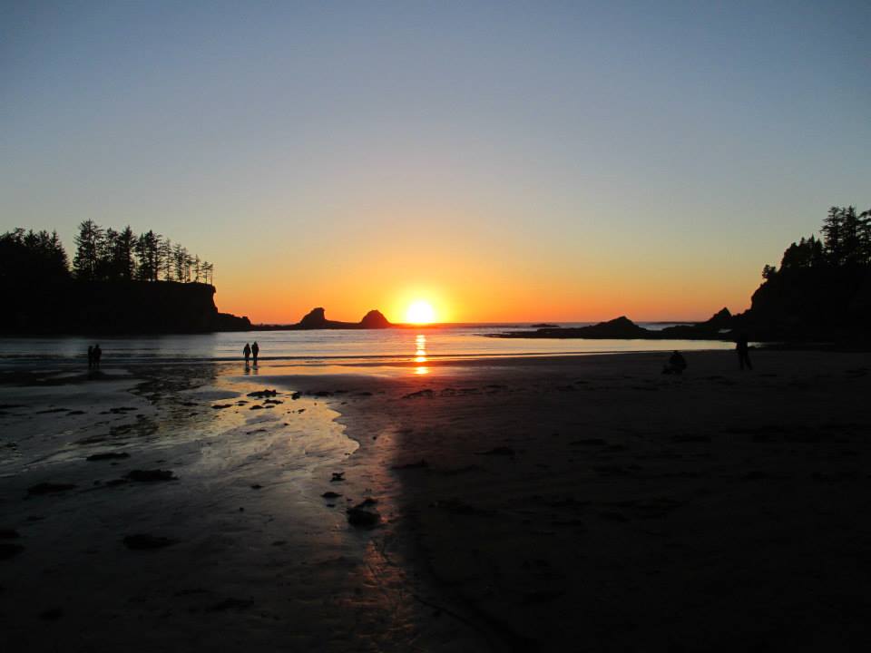
- 2. The cliff above the ocean is to the west (obviously) and has a pavilion. This is a fantastic place for storm watching. This picture was taken from this area.
- 3. On the north end of the parking lot is a paved trail. Don’t miss this! It’s only a short walk to some fabulous unique cliffs.
- 4. Simpson beach. On the south side of the parking lot, just before you get to the garden, there is a trail down from the cliffs to a sandy cove. It’s a bit of a walk.
Simpson Reef:
Just before Cape Arago (the end of the road) there is a pull off with a small parking lot that overlooks hundreds of seals and sea lions. You can hear them barking. It’s nice if you have binoculars to see them better. I’ve never been here and not seen sea lions and seals.
Cape Arago:
Cape Arago Hwy (the road that goes through Charleston) ends in a loop high up on cliffs. Several scenic views on the loop. A couple rugged paths to climb down the cliff to the beach.
On the south end of the loop is a paved trail to the beach. It’s a steep path, so remember if you go down, you have to come back up. This has the best tide pools on low tide. Besides the normal sea anemones, limpets and starfish, we have found sea urchins, chitons, and sea slugs. It’s a sandy and rocky beach usually with driftwood.
Sunset to Cape Arago Trail:
7-9 mile hike. Print off the pdf file following this paragraph, as the trail is not well marked. You start at Sunset Bay and walk the trails to Cape Arago which is the end of the road. Along the way, you see the forest, beaches, lookouts, a little bit of everything. There are enough hills along the way that you will get a good workout.
http://coostrails.com/coostrails/assets/sunset-to-cape-arago-trails.pages.pdf
Coos History Museum:
Small but interesting museum showcasing the history of Coos Bay and surrounding areas. Many exhibits of first-hand memories of the old timers from this area. It is on Highway 101 on the north end of Coos Bay. Well marked.
Website: http://cooshistory.org
Charleston Marine Life Center:
(This description from the internet.) Located on the edge of the harbor in Charleston, OR, the Oregon Institute of Marine Biology’s Charleston Marine Life Center is an exciting place for discovery. Aquaria highlighting different coastal ecosystems, a tidepool touch tank, whale and sea lion skeletons, underwater video from deep reefs and undersea volcanoes, and a variety of specimens reveal the hidden and remarkable diversity of life off Oregon, from the coast to the deep sea.
Five exhibit galleries focus on coastal ecosystems, deep-water habitats, fisheries, marine mammals, and ongoing marine research. From the CMLC’s windows, you can look out over the harbor as fishing boats unload their catch, and watch seals, sea lions, and birds a few feet away. Find out about ongoing marine biology research, check out a working ROV (Remotely Operated Vehicle), explore collections and zoom in with microscopes.
This is worth going to. It doesn’t cost much.
http://www.charlestonmarinelifecenter.com/
Mingus Park:
(description from the internet) Mingus Park is located just a few minutes walk from the downtown business district. The park has a lake as its centerpiece with an arboretum on the northwest side of the lake, the city’s municipal pool to the east, playgrounds to the south, an oriental flower garden to the west, and a skate park, tennis court and baseball field to the southeast. Mingus Park is a favorite with walkers who stroll along the paved trail that borders the water and winds through the tranquil Choshi Gardens. Children romp on the two playgrounds and visitors enjoy the picnic areas. Fountains in the center of the lake are lit with underwater lights at night, making them a beautiful feature in the late evening. Aquatic birds make the lake a home year-round.
There is a public outdoor pool on the north side of the park. To get there from highway 101, from downtown Coos Bay, turn west on Anderson or Commercial St (main streets with stoplights) (From the highway, you can only turn west, as the bay is east.) Turn right on 10th St. In just a few blocks, Mingus Park is on your left.
Farmer’s Market:
Wednesday morning in the summer they block off three blocks on Central Ave of Coos Bay and fill it with booths selling produce, crafts, and food. It’s fun. There are gift shops in that area of town too. If you go south on highway 101 through downtown Coos Bay, you will see it on your right. It runs from May through October, 9 AM to 2 PM. When the rains start, there are fewer booths. In the winter there are a few booths that meet in Pony Village Mall on Wednesdays.
Bandon is 25 miles south of here on highway 101
Coquille River Lighthouse:
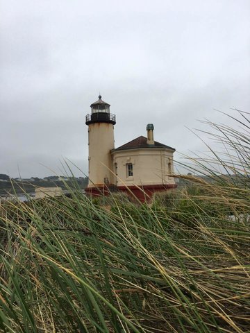
A local historic landmark which dates back to 1895 and offers panoramic views of the nearby beach and the ocean. Going south on 101 hwy, just before the bridge into Bandon, follow the signs to Bullards Beach. This is the best beach on the coast for finding driftwood.
Face Rock Creamery:
Amazing cheese factory. Watch cheese being made. Sample a dozen or so types of cheese and cheese curds. Huge yummy ice cream cones and tasty sandwiches. This is the best store in Bandon. It will be on your left just after you get to town. 680 2nd St. Bandon. They recently added a store in Coos Bay. You can Google it.
Old Town Bandon is the best place to stroll through gift shops. It’s on your right, a couple blocks after the Creamery.
Bandon beach is just past old town. It is beautiful with many rock formations. It is usually windy.
West Coast Game Park Safari:
This maybe ten miles south of Bandon on Hwy 101. It’s a small zoo. Many roaming animals. They usually have some baby animal, like a bear or tiger, to pet at certain times. Some of the cages are too small, so we feel sorry for some of the animals. 46914 US-101, Bandon, OR 97411
Wildlife Safari in Winston, Oregon.
This is a great zoo. There is a walk-though part and a drive-through part. Winston is east of here. You go south on 101, then turn east (left) on hwy 42 to Winston. It’s about 1.5 hour drive, almost to Roseburg and I-5.
The Redwoods

The magnificent redwoods are 2 1/2 hours south of here. Go south on 101 and into California. Spend the night in Crescent City. The Trees of Mystery is definitely worth the money. For no cost, the best drive is through Jedidiah Smith Redwoods State Park and Stout Rd. I don’t have details here, but you can Google them.